
Storms Return To MD Forecast As Oppressive Heat Lingers
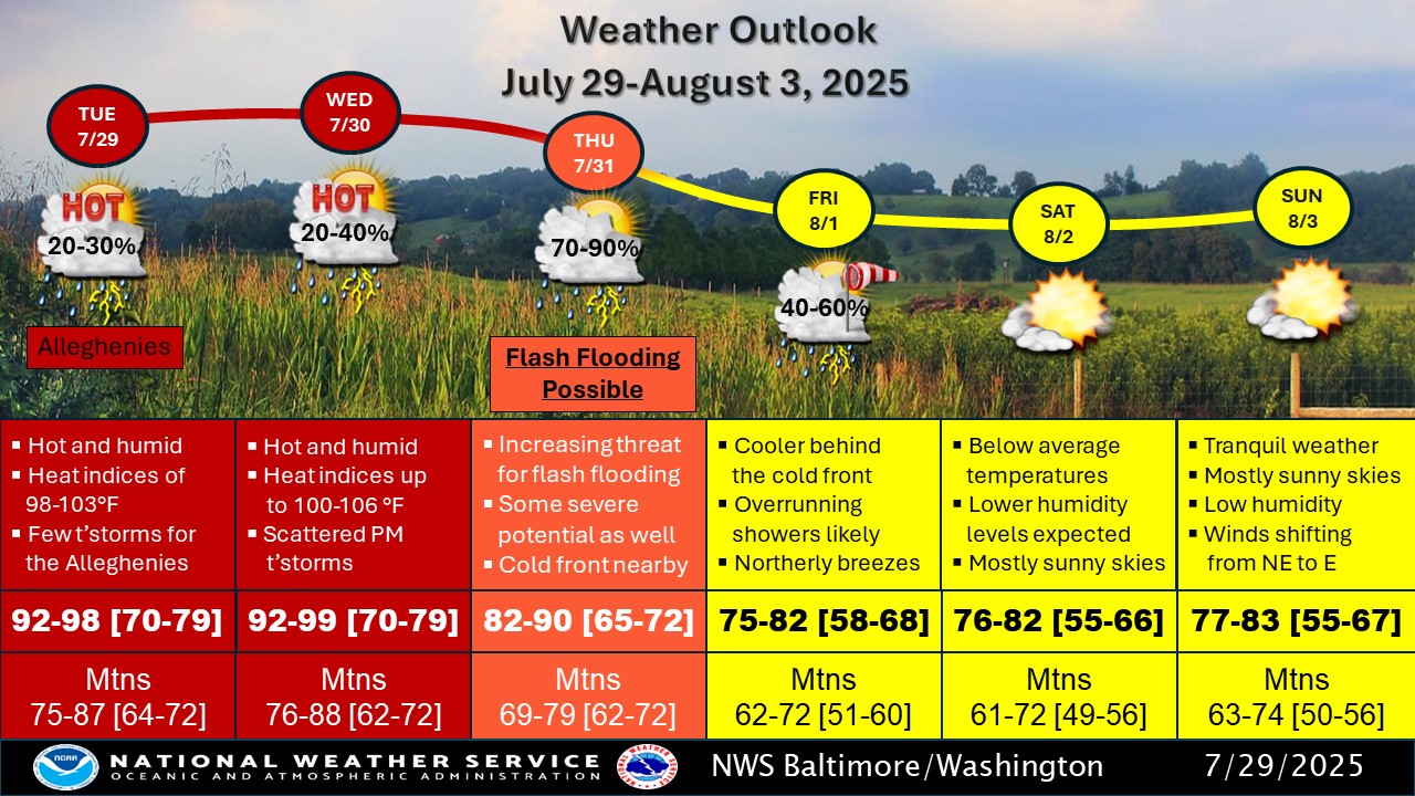
Maryland will see a couple more days of oppressive heat before storms return to the state and temperatures cool heading into the weekend. Heat advisories were in effect for portions of Maryland on Tuesday as temperatures in the Baltimore area were expected to climb into the mid- to high 90s. Heat indexes were also expected to reach 100 to 105 degrees.Wednesday will be the warmest day of the week, according to the Washington Post's Capital Weather Gang, with highs in the upper 90s, partly to mostly sunny skies, and high humidity. The National Weather Service issued a hazardous weather outlook for Wednesday, when heat index values of 105 to 109 degrees are possible east of the Blue Ridge, and 100 to 104 degrees west of the Blue Ridge during the afternoon hours.Heat Advisories have been issued for portions of the area west of the Blue Ridge where criteria of 100° is expected to be met. Those east of the Blue Ridge, where criteria for a Heat Advisory is 105°, are expected to stay mainly below Heat Advisory criteria. pic.twitter.com/C6ZNVcXWDh— NWS Baltimore-Washington (@NWS_BaltWash) July 29, 2025 "Hot temperatures and high humidity may cause heat illnesses," the NWS said. "Drink plenty of fluids, stay in an air-conditioned room, stay out of the sun, and check up on relatives and neighbors."Storm chances return to Maryland later on Wednesday. According to the Capital Weather Gang, a few isolated late-afternoon and evening thunderstorms are possible. Chances of rain and storms increase on Thursday as temperatures begin to cool. "Skies are partly to mostly cloudy with numerous showers and storms, mainly in the afternoon and evening," the Capital Weather Gang wrote. "It’s still sticky with highs in the upper 80s and low 90s."Because of increased rain chances, scattered instances of flash flooding are possible Thursday afternoon and evening, NWS forecasters said.By Friday, showers are expected to linger, but temperatures will cool significantly behind an incoming cold front. High temperatures on Friday will only reach the mid-70s to low 80s, a trend that will continue through the weekend.Here's the detailed NWS forecast for the Baltimore area:Tuesday: Mostly sunny and hot, with a high near 97. Heat index values as high as 102. Light south wind.Tuesday Night: Mostly clear, with a low around 77. Calm wind.Wednesday: Sunny and hot, with a high near 97. Heat index values as high as 103. Calm wind becoming south 5 to 7 mph in the afternoon.Wednesday Night: A slight chance of showers and thunderstorms. Partly cloudy, with a low around 76. South wind 3 to 6 mph. Chance of precipitation is 20%.Thursday: A chance of showers, then showers likely and possibly a thunderstorm after 2pm. Mostly cloudy, with a high near 90. Southeast wind 3 to 7 mph. Chance of precipitation is 70%.Thursday Night: Showers and possibly a thunderstorm. Low around 70. Chance of precipitation is 80%.Friday: Showers likely, mainly before 8am. Mostly cloudy, with a high near 77. Chance of precipitation is 60%.Friday Night: Mostly cloudy, with a low around 65.Saturday: Mostly sunny, with a high near 82.Saturday Night: Mostly clear, with a low around 64.Sunday: Sunny, with a high near 83.The article Storms Return To MD Forecast As Oppressive Heat Lingers appeared first on Bel Air, MD Patch.
Welcome to Billionaire Club Co LLC, your gateway to a brand-new social media experience! Sign up today and dive into over 10,000 fresh daily articles and videos curated just for your enjoyment. Enjoy the ad free experience, unlimited content interactions, and get that coveted blue check verification—all for just $1 a month!
Account Frozen
Your account is frozen. You can still view content but cannot interact with it.
Please go to your settings to update your account status.
Open Profile Settings